
A Brief History…
 |
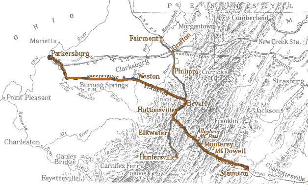
The Staunton-Parkersburg Turnpike
is an historic road from Virginia’s upper Shenandoah Valley to the
Ohio River. Begun in 1838 and completed by 1850, it was designed by
master engineer Claudius Crozet. The turnpike was the gateway to the
Shenandoah Valley and was prized by both Union and Confederate
armies during the Civil War as essential for control of western
Virginia. Today, much of the route follows modern highways. Other portions are original back roads that offer excellent opportunities for visitors to experience the turnpike much as it was 150 years ago. The turnpike begins in Staunton, Virginia and follows US 250 through Augusta and Highland Counties. Crossing into West Virginia, it passes through Pocahontas and Randolph Counties in the high Allegheny Mountains of central Appalachia. It continues westward along valleys and ridges on old US 33 into Upshur and Lewis Counties, then WV 47 through Gilmer, Ritchie, Wirt, and Wood Counties. |
The West Virginia portion is designated a National Scenic Byway and a West Virginia Byway.
Learn more at the Staunton-Parkersburg Turnpike exhibit “Travel a Turnpike through Time” and at the Beverly Heritage Center in Beverly, West Virginia.
You can also read "A
Slightly Longer History" and " Some
Turnpike Facts," below.
For the best, in-depth account, our 36-page history booklet is available at
the Turnpike Gift Shop.

| …that a turnpike is a public or
private roadway for which a fee (or toll) is assessed for passage? Along the
road were strategically-placed tollhouses, like where a valley narrowed or
there was only one way to cross a stream. Travelers were forced to stop
because there was a long pole (or pike) across the road. It was situated on
a post that allowed the tollhouse keeper to pivot or turn the pike, allowing
passage once the toll was paid. Tolls helped with the cost of road
construction and maintenance.…the turnpike travels across nine counties? Traveling east to west, it runs
through Augusta and Highland counties in Virginia; and Pocahontas, Randolph,
Upshur, Lewis, Gilmer, Wirt, and Wood counties in West Virginia. …that the West Virginia portion of the Staunton-Parkersburg Turnpike is a state scenic byway and a National Scenic Byway? …that in addition to the byway, there are four backways? There’s Camp Allegheny and Back Mountain backways in Pocahontas County, and Cheat Mountain and Rich Mountain backways in Randolph County. Most of the backways are on the original roadbed of the turnpike and are gravel roads. It’s advised to travel these in a high-clearance vehicle, as well as in dry weather conditions. |
 |
…that chief engineer Claudius Crozet’s initial layout planned for the road grade to be no more than 4% (this means there should be no more than a four-foot rise with every 100 feet of road)? He didn’t succeed, although he tried. This is why the road makes so many curves and switchbacks – to try to reduce the climb and descent to a gentle 4%.

…that people, wagons, and
animals all had different tolls? A wagon, team, and driver was 25 to 55
cents; four-wheeled riding carriage, 20 to 45 cents; cart or two-wheeled
riding carriage, 12 ½ to 20 cents; man and horse 6 ¼ cents; cattle per head
¼ cent; sheep or hogs, 3 to 5 cents per score (20).
After decades of inaction
on the part of the Virginia government in
Richmond,
the state finally acceded to demands from its western citizens
and began to construct a turnpike into the interior. The road
was initially authorized in 1826, and planned and laid out by
the state engineer of Virginia, Claudius Crozet. It was not
actually built until the 1840’s, however, with completion of the
main roadway in 1848. This road, traveling over the high
mountains near the birthplace of rivers, was an engineering
marvel, and opened up large sections of western Virginia to
settlement and commerce.
One of the earliest campaigns of the Civil War was fought for control of this turnpike, and the access it provided to the B&O Railroad. The Battle Of Rich Mountain gave the Federals control of the turnpike, of the Tygarts Valley, and of all of the territory of western Virginia to the north and west, including the railroad. Union General George McClellan’s victory brought him promotion to command the Army of the Potomac. The Federals then fortified at Cheat Summit, and the Confederates established fortifications at Bartow and Allegheny. There they faced each other over the turnpike through the fall 1861 and over the winter. General Robert E. Lee’s attempt to attack Cheat Summit Fort, and Federal attempts to attack Camp Bartow and Camp Allegheny, all failed to dislodge the enemy.
But the harsh winter in the mountains achieved what armies had failed, and in the spring of 1862 both armies moved on down the pike to the battle of McDowell, and on to fight what became Stonewall Jackson’s Shenandoah Mountain campaign. Two years later much of the area crossed by the Pike became part of the state of West Virginia.
|
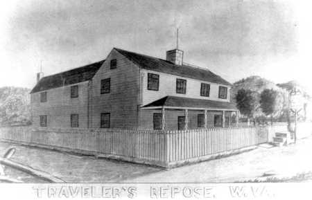
Following the war, control and maintenance of the road was delegated to the counties, and damage to the road and bridges was slowly repaired. Tolls continued to be collected, at least in some areas, until the 1890s. Travel, mail, and stage routes resumed, and bringing business to inns such as Traveller’s Repose near Camp Bartow and the hotels in Beverly. |
"Traveller's Repose" -- long-time turnpike stop at Bartow, W.Va.
|
With the coming of the railroads in the 1890s and early 1900s, new towns were founded and thrived. The lumbering and coal industries brought prosperity to the region. The turnpike itself declined in importance, but the theme of the role of transportation into the mountains remained paramount.
In the 1920s and 1930s, highways were paved to provide for automobiles. Many sections of the original turnpike remained the best available route, and the turnpike was paved as the highway. In Pocahontas and Randolph counties, today it mostly follows US Rt 250 as far as Beverly. In some cases, newer construction techniques allowed alternative routes, and sections of the turnpike were bypassed.
-
WHAT IS A TURNPIKE?
A turnpike is a toll road; in other words people had to pay to use the road. At intervals along the road there were tollhouses. These were strategically placed to avoid efforts to bypass the tollhouse. They were at places where the valley narrowed, where there was only one way to cross a stream, or simply at regular intervals where a person was willing to be a toll collector.
Someone was always in the tollhouse to collect fees. Travelers were forced to stop because there was a long pole, or pike across the road. The pike was situated on a base post that allowed the toll house keeper to pivot or turn the pike to allow passage after the toll was paid. Hence the name Turnpike.
The purpose of collecting fees was to pay for maintenance on the road. As it turned out, the money collected did not cover this cost, especially when a storm washed out part of a road, or a bridge needed to be replaced.
-
WHAT WERE THE FEES TO USE THE ROAD?
People, wagons, and animals all had different tolls, and the costs varied through the years. A wagon, team, and driver, 25 to 55 cents; four-wheeled riding carriage, 20 to 45 cents; cart, or two-wheeled riding carriage, 12 ½ to 20 cents; man and horse 6 ¼ cents; cattle per head ¼ cent; sheep or hogs, 3 to 5 cents per score (20).
-
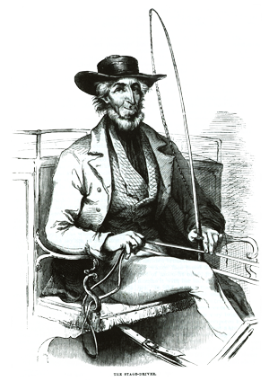
RIDING THE ROAD - See an early ad for stagecoach travel
-
WHY DOES THE ROAD WIND SO MUCH?
Some of the Staunton Parkersburg Turnpike followed old Indian trails. Indians had lived here for thousands of years, and knew the easiest way to walk from one place to another. The way to get from one spot to another often is not a straight line. Their trails followed the contours of the land. When it came to crossing streams, they often went upstream to a point where crossing was safe and easy. To go over mountains, they crossed at the lowest point or saddle of a ridge.
Early explorers found these ancient routes to be the safest and easiest ways to travel whether on foot or on horseback. So Indian foot trails became horse trails, and later these became roadways, and still later the roadway became the Turnpike.
-
WHO BUILT THE TURNPIKE?
At the time the Turnpike was built, there was no West Virginia. We were part of Virginia. So it was the Virginia Chief Engineer, Claudius Croset who surveyed the road. He often followed the old Indian trails. His mission was to lay out a route for a road from Staunton to Parkersburg, and the road should have a grade of no more then 4%. This means there should be no more than a 4 foot rise with every 100 feet of road:
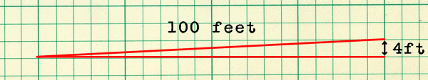
If you drive the
Turnpike through the mountains, you realize that he did not
succeed in this request, although he tried. This is why the
road makes so many curves and switchbacks, to try to reduce
the climb and descent to a gentle 4%.
Local workers did the actual building. The Turnpike was
divided into 20 mile segments, and each segment was awarded
to a local contractor, who then hired local people to work
on the road. The contractor paid these workers. Overseers
earned $31 a month, wagoners $15 per month, blasters,
blacksmiths, and wall builders earned $12-$13 per month.
Laborers made up the majority of the workforce earning
between $7.50 and $10 per month. The lowest paid workers
were cart drivers at $8 and cooks at $6 per month. Some of
the 20 mile segments were in the valleys, on relatively flat
ground, and some were over the mountains, and harder to
build and supply. The work started at either end, and they
worked toward the middle. The last segment to be completed
was between Buckhannon and Weston. The road was complete in
1845.
Bridges were separate contracts. Lemuel Chenoweth was an
excellent bridge builder, and he was the successful bidder
on many of the bridges along the route. He built the bridge
that was once in Beverly, and you can still admire his work
in the famous Phillippi covered bridge. The bridges were
complete in 1849.
A NEW GOVERNMENT
After Virginia seceded from the Union, the loyal
Virginians set up a Restored Government of Virginia in
Wheeling. As a new state government, they had no money for
urgent expenses - or anything else!
Shortly before war had broken out, the rebel Virginia
government in Richmond had sent funds to Weston for the
construction of the Trans Allegheny Insane Asylum.
In June of 1861, Governor Peirpont, newly elected by the
Restored or Loyal Government of Virginia, ordered the money
to be seized and transported to Wheeling.
In response, General Mc Clellan sent a detachment of Ohio
Volunteer Infantry to Weston under the command of Col.
Tyler. Tyler and his troops camped on the grounds of the
unfinished hospital, then marched to the bank to force the
surrender of the money. This money was intended for miner’s
payroll and for hospital construction. The soldiers
recovered $27,000 in gold.
The new Governor considered this action merely a
reappropriation of Virginia funds. That much gold is
extremely heavy, so the money was transported in a hearse.
It was one of the best guarded "funeral" processions ever!
This event is still celebrated at Weston in June of each
year.